Fusion Atlas and Autofly Integration
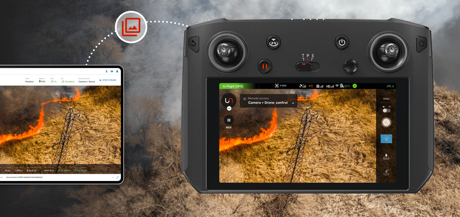
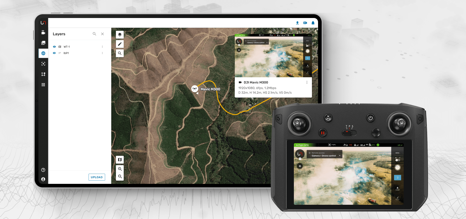
Unleash live continues to redefine the frontiers of real-time data analysis and geospatial intelligence. Fusion Atlas, integrated with the Autofly platform, now enables users to display drone and camera positions on a map while viewing live video streams simultaneously.
This groundbreaking geospatial feature is transforming how industries operate, particularly in emergency services and incident response operations. The real game-changer, however, lies in Fusion Atlas's ability to provide full situational context by integrating high-resolution satellite imagery, orthomaps, and linework such as KML/KMZ and shapefiles.
Fusion Atlas: Providing Comprehensive Situational Context
Fusion Atlas, a product of Unleash live, is a powerful geospatial intelligence platform that provides real-time insights and analytics from drones, cameras, and other IoT devices. The latest feature in Fusion Atlas takes its capabilities to a new level by allowing users to view drone and camera positions in context with high-resolution satellite imagery, orthomaps, and linework such as KML/KMZ and shapefiles.
This feature provides a comprehensive overview of the operational environment, enhancing situational awareness and enabling efficient planning and decision-making. Users can see where their drones and cameras are and the broader context in which they operate. This comprehensive view of the operational environment is invaluable for industries ranging from construction and infrastructure to emergency services and environmental monitoring.
Autofly: Drone Automation
To leverage this new feature, users must use Autofly, another innovative product from Unleash live. Autofly is a drone automation platform that enables users to plan, execute, and manage drone operations easily. Autofly provides a seamless interface for controlling drones, capturing data, and transmitting it back to the user in real-time. With Autofly, users can set up drones to capture and display data from specific locations on the Fusion Atlas map.
Integrating Autofly with Fusion Atlas means that users can see where their drones are and what they see in real-time.
Fusion Atlas and Autofly integration
Use Case: Emergency Services and Incident Response Operations
The benefits of Unleash live's Fusion Atlas and Autofly are particularly significant for emergency services and incident response operations. Real-time collaboration and centralized control can make the difference between success and failure in these high-pressure environments.
With Fusion Atlas and Autofly, emergency teams can quickly deploy drones to assess a situation, with the live video feed providing real-time data to both field and office teams. This allows for quick assessment of the situation, efficient allocation of resources, and coordinated response efforts.
Moreover, the ability to view drone and camera positions in context with high-resolution satellite imagery, orthomaps, and linework provides a comprehensive understanding of the operational environment. This full situational context can be crucial in emergency situations, where understanding the broader environment can be as important as understanding the specific incident.
Geospatial Intelligence Advancements and Benefits
Integrating Fusion Atlas and Autofly revolutionizes geospatial intelligence by comprehensively understanding the operational environment. This full situational context is crucial in emergencies, enabling real-time collaboration and centralized control.
The benefits extend to various industries, from energy, mining, and environmental monitoring, where capturing real-time data from drones and other IoT devices drives informed decision-making and cost optimization. Unleash live's innovative products pave the way for a future where technology and data are seamlessly integrated into our everyday decision-making processes.