From emergency response and public safety to managing assets across vast geographies, the need for teams to communicate, share information, and solve complex problems under time pressure is inevitable. Add legacy systems, uncertainty of asset locations, and other variables to the equation, and the pressure levels rise. Now, with the Unleash Live and Esri partnership, the syncing of geographic information systems (GIS) and computer vision analytics empowers organizations to make better and faster decisions than ever before.
In the past, it has been near-impossible to analyze and derive insights from imagery through traditional means accurately. The sheer scale of data collected, changing variables such as images taken from different angles, variation of light over time, or inaccessible or unsafe locations mean that traditional data collection and analysis forms can be inefficient or ineffective. Unleash live’s computer vision fused with Esri’s ArcGIS mapping capability has created an enormous shift in managing assets and projects - no matter where the teams, locations or assets are.
The straightforward integration between the two software platforms gives a live digital asset map for A.I. insights that allows organizations to identify problems, manage and respond to events, set priorities, monitor change, perform forecasting, and understand trends much faster and with better end results.
Unleash live integrations are available with esri, Tableau and more

A roadmap for success
Many organizations, including local and state authorities, invest heavily in Esri’s solutions to better understand and manage their services, such as public transport and public safety and emergency response services, such as rural fires. This technology allows access to up-to-date information for disaster and crisis teams, providing capabilities such as managing responses with live feeds and sensor data to facilitate faster decision-making. Examples of sources that feed data into the platform from which insights are pulled include but are not limited to:
-
storm reports;
-
current gauge levels and;
-
road closures due to flooding data.
But the opportunities are across all industries and are, in effect, endless. It's an incredibly important and exciting time to explore these possibilities to boost productivity, effectiveness, and ease of collaborating and reporting.
A graduation to the Esri Partner Network
Esri, a world leader in location intelligence and mapping technologies, offers a unique Startup Program enabling the most promising emerging businesses to incorporate these innovations into their services and solutions. The program provides online services, training, support, and software to jumpstart development and aid in the discovery of innovative spatial solutions.
Recently, Unleash Live has graduated from the three-year Startup Program, earning the honor of being named an Esri Bronze Partner - a testament to the commitment to offering market-leading and custom solutions. This partnership enhances collaboration with Esri to help customers maximize their GIS and location technology investments. The Esri Partner Network (EPN) is a global partner ecosystem that delivers content, solutions, and services to help customers realize the benefits of GIS software and location intelligence (LI). Esri partners are at the forefront of innovation, embracing the latest technology.
"This partnership integrates best-in-class ArcGIS technology with Unleash live’s products is a testament to the commitment of offering market-leading and custom solutions."
- James Kwong, Unleash live Product Leader
Data-driven decisions: Unlocking the full potential of GIS
GIS is a system that creates, manages, analyzes, and maps all data types. It connects data to a map, integrating location data with all types of descriptive information. This provides a foundation for mapping and analysis in science and almost every industry.
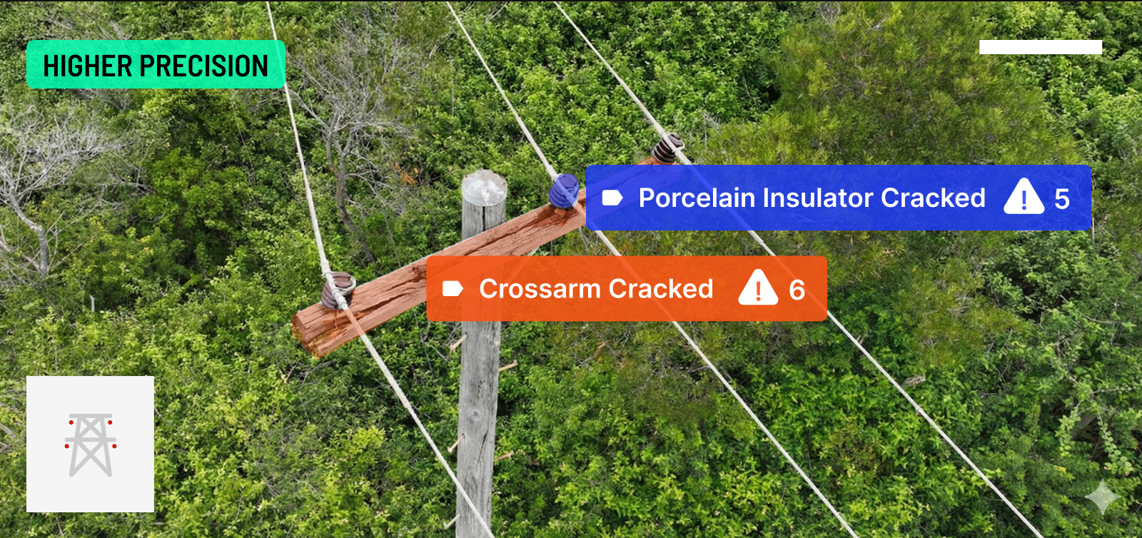
GIS helps users understand patterns, relationships, and geographic context. The benefits include improved communication and efficiency and better management and decision-making. With object detection, GIS finds what is in camera imagery, whether satellite, aerial, or drone imagery, locating it and plotting it on a map. This can be used for infrastructure mapping, anomaly detection, and feature extraction.
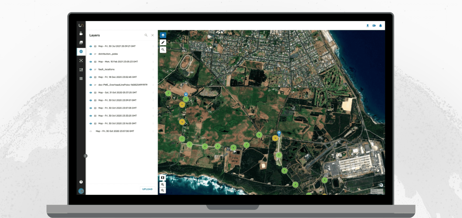
Fusion atlas - your digital asset map
Fusion Atlas, Unleash live’s digital asset map, combines rich contextual data such as approved access roads, environmentally sensitive areas, and landowner parcel data. Unleash live recognizes getting accurate, timely data is absolutely essential. But often, the data feeds organizations obtain lack the detail afforded by imagery - the answer to fast and accurate insights lies in data analytics.
Take, for example, the task of inspecting a pipeline; the combination of drone imagery and Unleash live's powerful mapping and modeling technology provides a complete solution through which inspection teams can reduce the time required to inspect pipeline construction, regeneration, and Right of Way (ROW) compliance. The captured images are processed on the account to create an accurate 2D ortho mosaic, 3D model, and point cloud for analysis by the inspection staff, engineers, or project managers from any connected environment.
Multiple layers of analyzed video and map data combine to create the insightful views within Fusion Atlas

Unleash live’s Fusion atlas supports in the following ways:
-
Fast decision-making: Images, videos, and orthomaps are geospatially placed on Fusion Atlas for contextual oversight and analysis. Use layers to highlight faults and annotate areas of interest to analyze and track changes.
-
Collaboration in real-time: Coordination and collaboration across many stakeholders with Live Esri integration enables business units to operate independently while working off the same data source.
-
Scaled capability: Enable experts with greater oversight by having a complete picture of your aspects of interest available in layers from any location or device.
The Unleash live platform allows integration into industry-standard systems such as ARC GIS to complement existing workflows and software packages. This allows information to be easily shared between GIS specialists and field operators, supports all commonly used formats, and includes relevant information that gives geospatial context to collected images and videos. This means that leaders can make decisions from near or far accurately and quickly. Contact us for more information or a demonstration.